What Is Utility Potholing and Daylighting?
Utility potholing — also called daylighting — is the process of excavating a small, precisely located test hole using vacuum excavation (soft dig) methods to physically expose an existing underground utility. Once exposed, the utility's exact depth below grade, outside diameter, material type, and condition can be measured and documented with certainty.
Potholing is the gold standard for utility verification. While electromagnetic locating and GPR scanning provide estimated horizontal position and approximate depth, only a physical test hole provides the precise, defensible data your engineers and project managers need to make design decisions, confirm clearances, and satisfy permit and contract requirements.
In Subsurface Utility Engineering (SUE) terminology per ASCE 38-02, a vacuum excavation test hole that exposes a utility and records its exact attributes constitutes Quality Level A (QL-A) — the highest level of utility data accuracy available. This data is what separates a defensible project from a liability exposure.
Construction Potholing and Potholing for Underground Utilities
Construction potholing is a standard pre-construction requirement on projects across South Florida where new infrastructure must cross or parallel existing underground utilities. Unlike desktop records or surface geophysics alone, potholing for underground utilities delivers certainty: the utility is physically exposed, measured, and photographed at the exact crossing point your design team needs to verify. Potholing companies like US Utility Potholing specialize in performing these test holes efficiently — often completing 6–12 holes per mobilization — minimizing cost while delivering the QL-A data your project requires. Whether it's hydrovac potholing using our vac truck in open ROW or vacuum potholing with our barrel and air compressor system in access-constrained environments, we have the equipment and crew to complete your test hole program on schedule.
When Potholing Is Required in South Florida
Civil engineers, general contractors, and municipalities across Broward, Miami-Dade, and Palm Beach County specify utility potholing in a wide range of project conditions:
- Design-phase conflict resolution: A proposed pipe, duct bank, or structure crosses a utility shown in as-builts. Before finalizing design, the engineer needs the utility's actual depth — not the as-built estimate, which is frequently wrong in South Florida.
- Pre-bore clearance: Horizontal directional drilling (HDD) contractors in South Florida require verified utility depths along the bore path before drilling to confirm clearance from existing infrastructure.
- Deep foundation conflicts: Drilled shafts, micropiles, helical piers, and caissons near existing utilities require confirmed clearance before installation to prevent structural damage to buried lines.
- Electrical utility clearance: Power companies require verified clearances when new facilities cross or parallel existing underground electrical infrastructure.
- SUE QL-A deliverables: Project owners and agencies specifying ASCE 38-02 compliance require physical daylighting at critical utility crossings to achieve Quality Level A designation.
- Municipal permit conditions: Many Broward County and Miami-Dade municipalities require potholing documentation for work within utility-dense right-of-way as a condition of permit issuance.
Our Potholing Process: From Test Hole to Documented Data
Every potholing engagement begins with a thorough private utility locating sweep of the project area to identify all utilities present and position test holes at the most critical crossing points. We then proceed through a systematic field process:
- Test hole positioning: Holes are located at utility crossing points, conflict areas, and critical design clearance zones specified by the engineer of record.
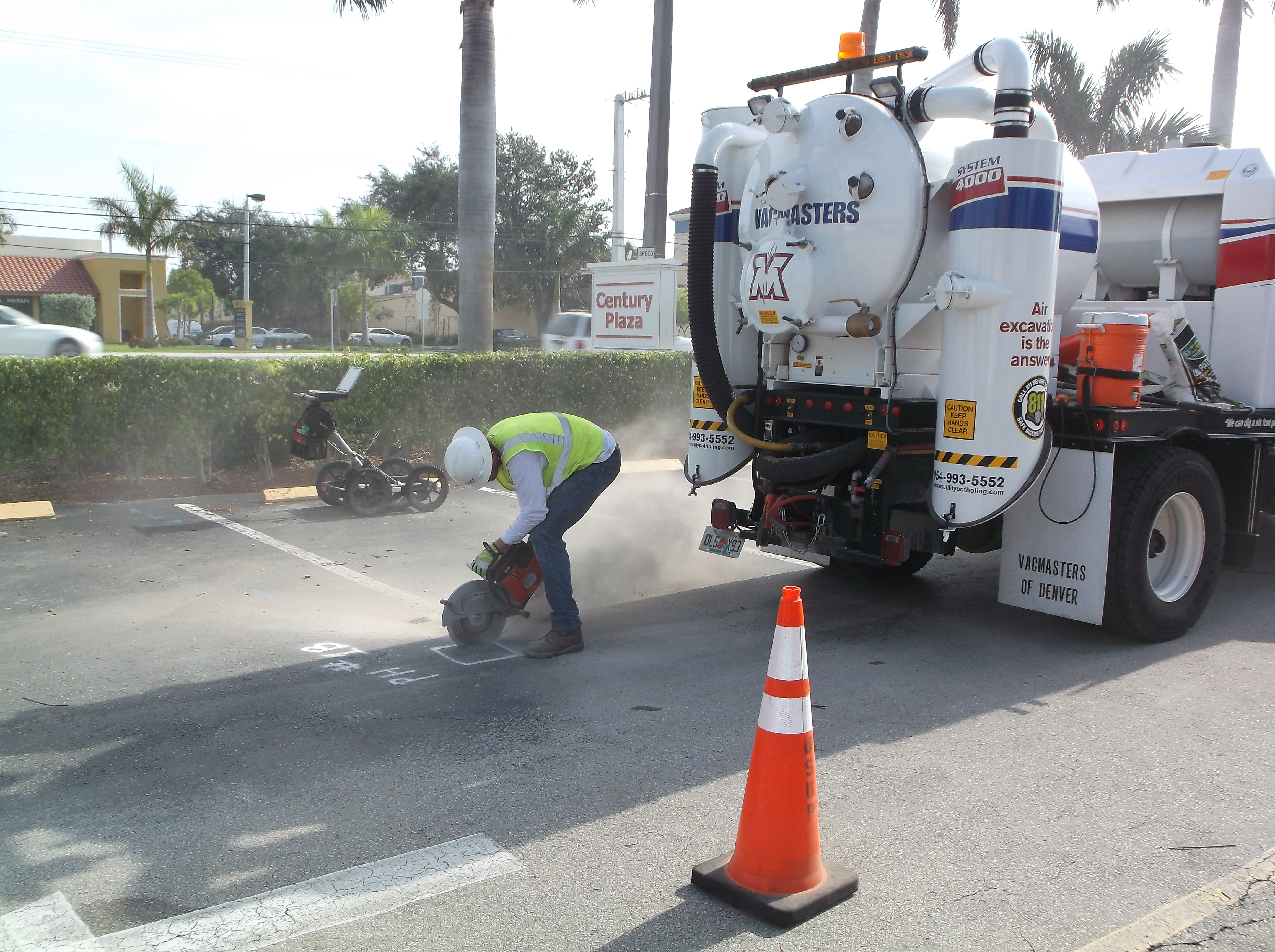
- Surface preparation: Pavement cutting (saw cut or core) as required for paved areas in South Florida's urban ROW.
- Vacuum excavation: Non-destructive soft dig using our vac truck or barrel/air compressor method to expose the utility without mechanical contact.
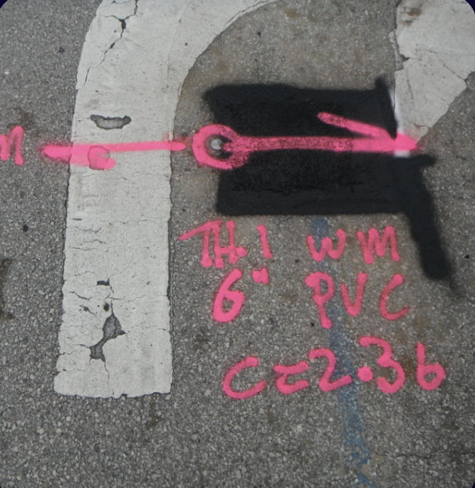
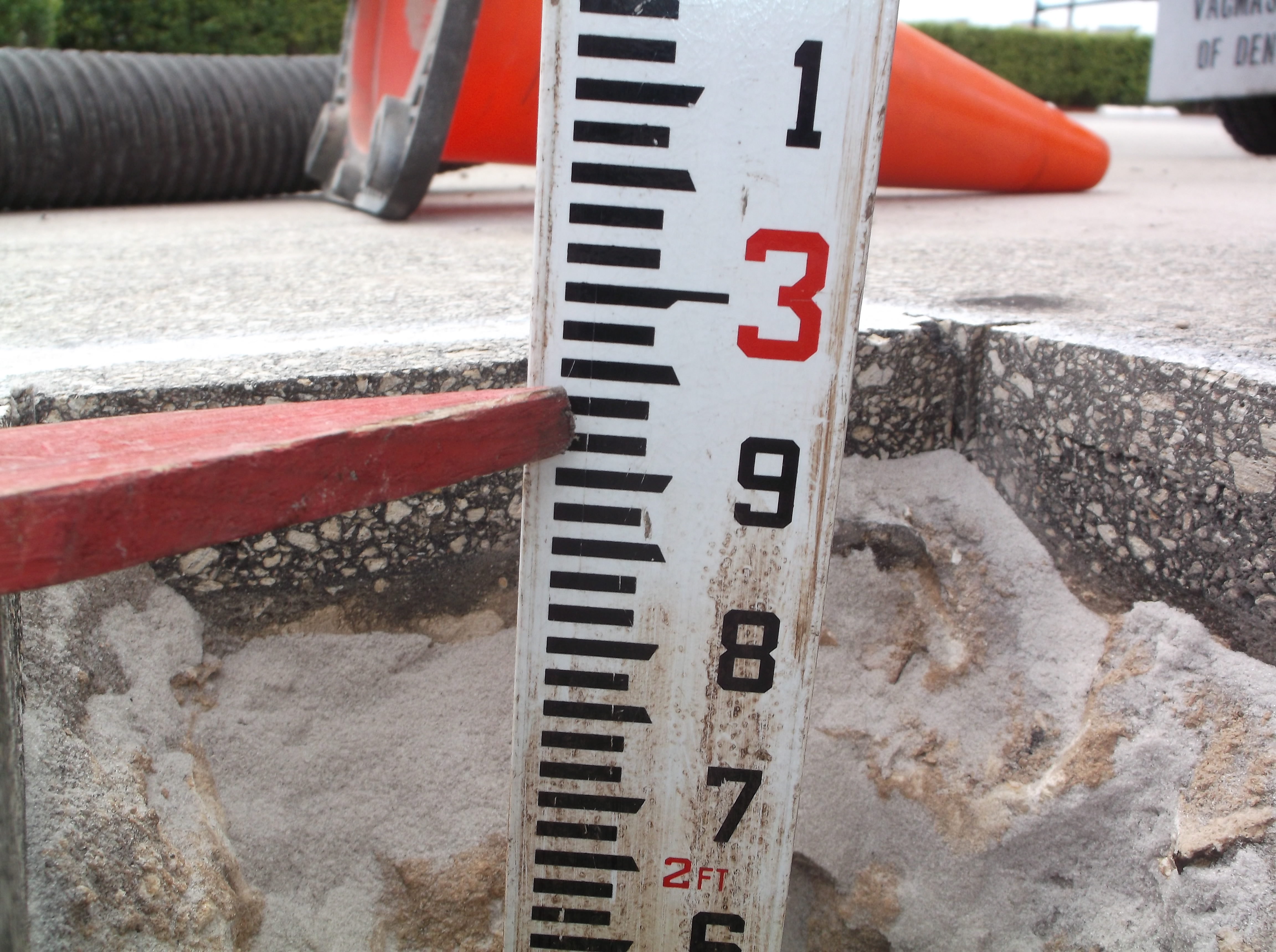
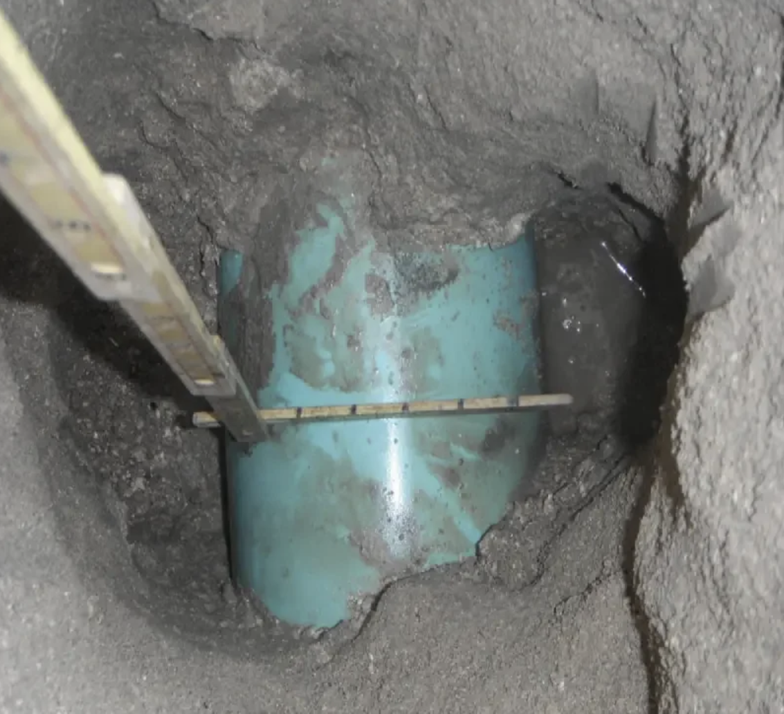
- Utility measurement and documentation: Depth to top, depth to centerline, outside diameter, material type, and condition are measured and recorded. GPS coordinates are captured for each test hole.
- Photographic documentation: Each exposed utility is photographed in the hole for the project record.
- Backfill and restoration: Test holes are backfilled, compacted, and surface-restored to match existing conditions. Cold patch asphalt provided for paved surfaces.
- Deliverable package: Field data sheet with all measurements, GPS coordinates, and photographs delivered to the project team. Can be integrated into CAD for utility mapping.
ASCE 38-02 Quality Level A: What It Means
The ASCE 38-02 standard defines four Quality Levels for subsurface utility information:
- Quality Level D (QL-D): Information from existing records only — lowest confidence.
- Quality Level C (QL-C): Surveyed surface features (valve boxes, manholes) correlated to utility records.
- Quality Level B (QL-B): Two-dimensional horizontal position determined by surface geophysics (EM, GPR).
- Quality Level A (QL-A): Three-dimensional position verified by physical vacuum excavation test hole — the highest accuracy standard.
Our potholing services deliver QL-A data at the exact locations your project requires. Combined with QL-B locating, we provide a complete ASCE 38-02 SUE dataset for your engineering team.